
India’s Water Security: Geopolitics and Climate Change

This article explores India’s water security challenges—from transboundary river disputes and groundwater stress to untreated wastewater and climate change—and outlines strategies for resilient and cooperative water management.
Authored by Shibabrata Chakraborty, a water sector consultant with experience working with governments and financial institutions across India and globally on project structuring, service delivery, and institutional capacity.
India, with 18% of the global population but with only 4% of its freshwater resources, faces a deepening water security crisis. Ranked the 13th most water-stressed country and 120th in water quality, India’s challenges stem largely from rapid urbanization, industrial growth, unsustainable agricultural practices, and over-reliance on groundwater. Per capita water availability has plummeted from 5,200 cubic meters in the 1950s to under 1,500 in recent years (2021) – classifying India as a water-stressed country.
Water stress has far-reaching impacts on public health, the environment, and economic growth. Further compounding the problem is the fact that 70% of urban wastewater remains untreated, polluting rivers and land—contributing to 91% of 302 surveyed river stretches being contaminated and leading to degraded ecosystems. Waterborne diseases contribute to millions of illnesses and substantial economic losses annually. Groundwater over-extraction—on which 85% of rural drinking water depends—has severely depleted aquifers, especially in northern India. Encouragingly, recent trends show a slight recovery: groundwater recharge has risen by over 3%, extraction has declined by about 1%, and more aquifers are now classified as ‘safe’. Yet, water scarcity continues to threaten agricultural livelihoods, drive internal migration, and disproportionately burden women and children, making it a central issue for social equity and national stability.
This article also examines two critical dimensions of India’s water security: risks arising from transboundary river sharing and the intensifying impacts of climate change. With key rivers shared with neighboring countries like China, Pakistan, and Bangladesh, issues around water sharing, upstream damming, and pollution have geopolitical implications. Simultaneously, climate change acts as a powerful threat multiplier—through altered monsoon patterns, accelerated glacial melt, and rising sea levels—further straining water availability and quality. These factors compound existing pressures and require India to adopt an integrated, forward-looking strategy for resilient water governance.
Geopolitical Dimensions: Transboundary Water Risks
India’s water security is inextricably linked to its transboundary river basins, which are shared with neighboring nations. The management, or mismanagement, of these shared resources by upstream or downstream riparian states can introduce significant geopolitical tensions and directly impact India’s water availability and quality.
Brahmaputra River Basin: China’s Upstream Influence
The Brahmaputra River, known as the Yarlung Tsangpo in Tibet and the Jamuna in Bangladesh, is a critical transboundary waterway. Its vast basin supports millions of people in Northeast India, playing a vital role in regional water security, agriculture, and biodiversity. China has officially approved the construction of the Medog Hydropower Station on the lower reaches of the Yarlung Tsangpo in the Tibet Autonomous Region. Reported estimates of the Medog Hydropower Station’s cost and capacity vary, with some sources suggesting it could surpass the Three Gorges Dam in scale, though exact figures remain unconfirmed. The dam’s location near the river’s “Great Bend” in Medog County, in close proximity to the Line of Actual Control (LAC) with India, is strategically significant due to the river’s steep descent, which offers immense hydropower potential.
These upstream developments raise substantial hydrological concerns for India. Indian scientists and policymakers are apprehensive that the operation of these dams, primarily for electricity generation, will profoundly alter the river’s natural seasonal flow. This could lead to reduced water availability during the dry season and unpredictable, sudden releases of water during monsoons, thereby intensifying both water scarcity and flooding downstream in India. There are concerns among Indian policymakers about potential upstream control over the river’s flow, including the hypothetical use of water as a strategic resource during tensions. Furthermore, the project could disrupt the river’s crucial sediment flow. The Yarlung Tsangpo Grand Canyon supplies approximately 45% of the Brahmaputra’s total sediment volume. If the dam’s design bypasses the canyon, it could reduce this vital sediment supply to the lower reaches, severely impacting the vast delta and potentially accelerating coastal erosion, making it more vulnerable to sea-level rise.
Beyond hydrological impacts, the proposed dam site is located in one of the world’s most seismically active regions, raising significant concerns about the risk of a “great earthquake” breaching the dam. Large-scale infrastructure projects in the fragile Himalayan ecosystem are known to increase the likelihood of landslides and earthquakes, which can disrupt delicate ecosystems and threaten the diverse fish species (e.g., 218 fish species) that depend on the river.
A critical aspect of this transboundary dynamic is the absence of a formal water-sharing treaty between India and China. The existing Memorandum of Understanding (MoU) regarding transboundary rivers is non-binding and was unilaterally suspended by Beijing during the Dhoklam crisis, highlighting its fragility. While China provides some hydrological data (since 2006 for India, 2008 for Bangladesh), experts argue that such data-sharing agreements are insufficient to prevent potential water conflicts, especially given the lack of transparency.
India maintains a vigilant stance, “carefully monitoring” China’s dam projects. As a potential countermeasure, Arunachal Pradesh has proposed the 11,000 MW Lower Siang Dam, intended to regulate the Brahmaputra’s flow. However, this proposed Indian dam faces substantial local opposition due to fears of community displacement, severe ecological damage, and inherent seismic risks.
The situation in the Brahmaputra basin illustrates a fundamental tension: while large-scale hydropower projects are crucial for clean energy transitions and achieving carbon neutrality, their development on transboundary rivers can exacerbate geopolitical tensions and create severe environmental and social risks for downstream countries. This is particularly true in the absence of robust, legally binding water-sharing treaties and transparent data exchange. This dynamic necessitates a shift towards integrated basin management and multilateral cooperation that balances energy needs with environmental sustainability and equitable resource distribution across borders.
Indus River Basin: India-Pakistan Water Tensions
The Indus Waters Treaty (IWT), signed in 1960 and mediated by the World Bank, has long been regarded as a landmark water-distribution treaty governing the six rivers of the Indus basin between India and Pakistan. The treaty allocates the three eastern rivers (Ravi, Beas, Sutlej) to India for exclusive use, while the three western rivers (Indus, Jhelum, Chenab) are primarily allocated to Pakistan. India is permitted limited irrigation use and unlimited non-consumptive uses, such as power generation and navigation, on the western rivers, subject to detailed regulations for project construction.
India has announced the suspension of the IWT following the April 22, 2025 terrorist attack in Kashmir linked to actors based in Pakistan. Delhi explicitly stated its intention to hold the treaty “in abeyance” until Pakistan credibly and irrevocably ceases support for cross-border terrorism. This decision marks a notable departure from the treaty’s historical insulation from broader bilateral conflicts, which had previously allowed it to endure even during full-scale armed conflicts.
The suspension of the IWT carries several implications for India’s water infrastructure operations. With the treaty on hold, India has greater freedom to modify the operation of existing water-control infrastructure on the western rivers. For instance, Indian can now flush sediment from reservoirs of projects like the Kishenganga hydroelectric project outside the previously restricted peak monsoon period, which could significantly impact downstream farmers in Pakistan. Furthermore, India could cease sharing crucial water-flow data with Pakistan, hindering Pakistan’s ability to effectively plan and manage its own hydropower and flood-control infrastructure. In the longer term, India may accelerate the construction of larger projects on the western rivers, such as the Ratle (850 MW) and Kishenganga (330 MW) dams, which Pakistan has historically opposed, to store more water.
Pakistan is critically vulnerable to any disruption of the Indus River’s flow. Over three-quarters of Pakistan’s annually available renewable water resources originate outside its borders, almost entirely from the Indus River system. A staggering nine out of ten Pakistanis reside within the Indus Basin, relying on the river or its replenished groundwater aquifers for drinking water. Agriculture, which accounts for 94% of water withdrawals and contributes 22.9% to Pakistan’s GDP, is heavily reliant on the Indus system, irrigating over 90% of the nation’s crops. Pakistan also generates one-fifth of its electricity from hydropower, with all 21 hydroelectric plants located in the Indus Basin. Importantly, Pakistan has limited capacity to store water, retaining less than 10% of the river’s annual flow—substantially less than many other nations.
India’s suspension of the IWT has been viewed by observers as a strategic move, reflecting its upstream position and broader security concerns, including calls for action on cross-border terrorism and discussions on revisiting aspects of the treaty.
The IWT has long been upheld as a rare example of enduring water diplomacy, having withstood multiple decades of conflict between India and Pakistan by keeping water-sharing arrangements largely insulated from broader political tensions. India’s recent decision to place the treaty in abeyance, in the wake of grave national security concerns, reflects the evolving geopolitical realities of the region. In doing so, India has sought to underline that the effectiveness of such agreements must be contingent on mutual trust and an atmosphere free from cross-border hostilities. The move has brought global attention to the need for adaptive treaty frameworks that can respond to both hydrological and security-related challenges. As transboundary rivers increasingly intersect with national security considerations worldwide, there is growing recognition of the need for robust, resilient mechanisms that can ensure fair and sustainable water management while addressing broader regional dynamics. For India, which has upheld its treaty obligations for over six decades despite repeated provocations, this shift highlights a careful recalibration of policy in alignment with national interests and the imperative of safeguarding critical water resources.
Sharing rivers with Bangladesh: Ganga and Teesta
India and Bangladesh share over 50 transboundary rivers, with the Ganga and Teesta being among the most significant. These rivers are vital lifelines for both nations, supporting agriculture, livelihoods, and ecosystems across densely populated regions. Over the decades, water-sharing discussions have reflected a spirit of cooperation and regional stability, though evolving hydrological, climatic, and political conditions have introduced new challenges.
The 1996 Ganga Water Treaty stands as a landmark achievement in bilateral water diplomacy. It laid out a framework for equitable sharing of Ganga waters during the lean season, drawing on historical flow data and ensuring predictability for both countries. The treaty does not rigidly fix percentages but provides a flexible formula based on flow volumes. A Joint River Commission (JRC) was also established to facilitate cooperation, monitor flows, and resolve disputes.
As the treaty approaches its scheduled review in 2026, both sides have begun preliminary discussions for future arrangements. While Bangladesh has occasionally expressed concerns during exceptionally low-flow years, these instances have been addressed through diplomatic consultations, as provided for in the treaty. It is also increasingly recognized that climate variability and changing rainfall patterns—rather than unilateral actions—are primary contributors to seasonal water stress. India remains committed to fair and science-based sharing, and recognizes the need to build climate resilience into future frameworks.
Environmental concerns such as sediment transport and salinity intrusion in the delta region, particularly downstream of the Farakka Barrage, have been topics of joint technical discussions. India has reiterated that barrages like Farakka were constructed with mutual benefit in mind, particularly to ensure navigability in Kolkata Port. Nevertheless, both countries agree that long-term ecological shifts call for collaborative basin-level studies and potential adaptive strategies. The Teesta River issue remains unresolved despite substantial progress made during earlier rounds of negotiation. A 2011 draft agreement proposed a balanced formula that reflected seasonal realities and respective needs. However, water is a subject matter under the jurisdiction of individual states in India, discussions with the Government of West Bengal are still underway. India has conveyed its intent to find a mutually agreeable solution, acknowledging the developmental needs of Bangladesh’s northern districts.
In recent years, Bangladesh’s efforts to obtain funding from China for the Teesta River Comprehensive Management and Restoration Project (TRCMRP) have drawn significant attention. India has taken note of these developments and expressed willingness to partner on the project. The goal remains to ensure that any large-scale intervention on shared rivers aligns with broader basin stability and bilateral goodwill.
Beyond quantity, water quality and pollution control have emerged as shared concerns. As rivers traverse long distances and multiple jurisdictions, addressing pollution requires comprehensive planning and coordinated action. India is undertaking ambitious river rejuvenation programs such as the Namami Gange Mission, which aims to reduce industrial and sewage pollution through improved treatment infrastructure. Bangladesh’s concerns are acknowledged and form part of the agenda during JRC meetings.
The Ganges-Brahmaputra-Meghna (GBM) delta, shared by both countries, faces heightened risks from sea-level rise, land subsidence, and reduced sediment delivery. These challenges are not confined to any one side of the border. Climate change, land use transitions, and demographic pressures necessitate deeper scientific collaboration and joint adaptive planning.
India has consistently emphasized the importance of cooperative river basin management and has extended support for regional and multilateral engagement through forums such as the South Asia Water Initiative (SAWI) and discussions around the UN Watercourses Convention. A future-oriented water relationship between India and Bangladesh would benefit from enhanced data sharing, joint modelling, pollution control frameworks, and climate adaptation financing.
In sum, inter-country water governance between the two countries is at an crucial juncture. While past agreements like the Ganga Treaty have laid a strong foundation, new realities—ranging from climate variability to geopolitics —demand renewed commitment to dialogue, data transparency, and shared development.
The following table shows Key Transboundary River Basins and Associated Geopolitical Tensions–
| River Basin | Riparian States | Key Agreement | Core Disputes | Current Status/ Developments |
| Brahmaputra | India, China, Bangladesh | Memorandum of Understanding (MoU) | Upstream mega-damming, altered flows, sediment disruption, potential water weaponization | China’s Medog mega-dam approved, India monitoring and proposing Siang Dam; MoU unilaterally suspended by China in past. |
| Indus | India, Pakistan | Indus Waters Treaty (IWT) | Treaty suspension, altered operations, data sharing cessation, potential for water weaponization | India suspended IWT (April 2025) due to terrorism; Pakistan highly vulnerable. |
| Ganga | India, Bangladesh | Ganga Water Treaty (1996) | Lack of minimum guarantee, insufficient water share, climate variability impacts, upstream pollution, ecological impacts (sediment, salinity) | Treaty expiring 2026, renegotiation underway; Bangladesh concerns over climate variability and data. |
| Teesta | India, Bangladesh | Stalled Negotiations | Equitable water sharing, climate variability impacts, Chinese influence | Negotiations stalled due to concerns of West Bengal; Bangladesh collaborating with China on TRCMRP; India shown interest in counter-financing. |
Climate Risk: An Accelerating Threat to India’s Water Future
Climate change poses an accelerating and existential threat to India’s water security, exacerbating existing vulnerabilities and introducing new complexities. The impacts are observed across various hydrological systems, from monsoon patterns to glacial ice and coastal zones.
A. Changing Monsoon Patterns and Extreme Weather Events
India’s southwest monsoon (SWM), which supplies approximately 75% of the nation’s annual rainfall, has undergone significant and unpredictable changes in recent decades. The country has experienced increasingly irregular monsoon patterns, characterized by a heightened frequency and intensity of extreme weather events, including severe heatwaves, floods, and droughts. Forecasts suggest that increasingly dry summer monsoons and warmer winters will accelerate groundwater depletion in northern India, worsening water stress in regions that are already at risk.
These climatic shifts have direct and severe impacts on agricultural productivity, national food security, and the livelihoods of millions. Without effective adaptation strategies, rain-fed rice yields are projected to decline by 20% by 2050, wheat yields by 19%, and maize by 18%. This directly imperils national food security, particularly in a country where agriculture remains the primary source of livelihood for approximately 58% of the population. The tangible consequences are already evident: in 2024 alone, extreme weather events affected 3.2 million hectares of cropland and resulted in the death of nearly 10,000 livestock. The economic burden extends beyond direct agricultural losses; climate-related disruptions have compelled India to impose export restrictions on key food items, such as non-basmati white rice in July 2023. While aimed at bolstering domestic reserves, these restrictions have significant global ripple effects on food prices and international supply chains, disproportionately affecting vulnerable populations worldwide.
The data unequivocally demonstrates that climate change is not merely an environmental phenomenon but a direct and accelerating driver of socio-economic instability in India. Erratic monsoons and increased extreme weather events directly translate into reduced agricultural yields and damage to crops and livestock. Given India’s agrarian economy, this decline leads to significant livelihood loss for farmers and threatens national food security. The resultant food inflation and rural distress can trigger internal migration and exacerbate existing socio-economic inequalities and poverty. Government responses, such as export restrictions, while intended to protect domestic supply, have global ripple effects, highlighting the interconnectedness of national climate impacts with international markets. Therefore, climate adaptation in India must transcend isolated measures and be deeply integrated into broader economic and social development planning. The profound interconnectedness of climate, water, agriculture, and livelihoods necessitates a holistic, multi-sectoral approach that builds resilience across the entire socio-economic fabric, potentially leveraging tools like early warning systems and community-led adaptation strategies.
B. Himalayan Glacial Retreat and its Consequences
Himalayan glaciers, vital for sustaining India’s major rivers, are retreating at an alarming pace. This accelerated melting is primarily driven by rising temperatures, increased frequency and intensity of heatwaves, and erratic monsoons, which reduce snowfall and cause melting instead of accumulation in higher altitudes, diminishing glacier replenishment.
While initial glacial melt may lead to a short-term increase in river discharge and potential floods, the long-term and more critical consequence is a significant decline in base flows during dry months, particularly from April to June, as glaciers shrink. This reduction in meltwater threatens the year-round water supply for India’s major rivers, including the Indus, Ganga, and Brahmaputra, severely impacting agriculture, drinking water supply, and industrial use in the northern plains.
The accelerated glacial retreat also directly contributes to the formation of unstable glacial lakes. These lakes, often naturally dammed by moraines, can burst suddenly, triggering catastrophic flash floods downstream. The frequency of Glacial Lake Outburst Floods (GLOFs) has increased significantly since the 1900s and is expected to triple in the Hindu Kush Himalaya region by the end of the century, with several impacts likely surpassing the limits of adaptation. Noteworthy instances of such severe consequences include the Kedarnath disaster in 2013 and the Chamoli disaster in 2021, which resulted in significant loss of life and infrastructure.
Additionally, the shrinking of glaciers presents a significant risk to hydropower production. Many existing and planned hydroelectric projects in the Himalayan states rely heavily on consistent river flows. A long-term reduction in glacial contribution can severely affect power generation capacity, disrupt national energy planning, and negatively impact revenue for states like Himachal Pradesh and Sikkim.
The phenomenon of “peak water” is a critical, often overlooked, aspect of glacial melt. While accelerated glacial melt initially leads to increased river flows, which might be perceived as a temporary benefit for water availability, this is followed by a “peak water” point. After this threshold, river flow declines as the glacier’s mass diminishes. This means that regions currently benefiting from meltwater will face severe and sustained water shortages in the future, particularly during lean seasons, directly threatening vital sectors like agriculture, drinking water, and hydropower.
The increased risk of GLOFs adds an immediate, catastrophic dimension to this long-term depletion, threatening lives and infrastructure. Therefore, policy and infrastructure planning in India must shift from managing current water availability to proactively preparing for future scarcity, especially in glacier-fed river basins. This requires urgent investment in alternative water sources, stringent water use efficiency measures, and robust GLOF early warning and disaster preparedness systems, rather than being lulled into a false sense of security by initial increased flows.
C. Sea Level Rise and Coastal Vulnerability
Coastal regions in India face a critical threat from rising sea levels, which, combined with other climate impacts, severely compromise water security. Rising sea levels, driven by planetary warming, along with reduced groundwater recharge due to less rainfall and warmer weather patterns, are causing widespread saltwater intrusion into coastal groundwater aquifers. This process makes underground freshwater sources unsuitable for drinking and irrigation, while also damaging ecosystems and corroding essential infrastructure. Projections suggest that around 77% of coastal watersheds globally will be affected by 2100.
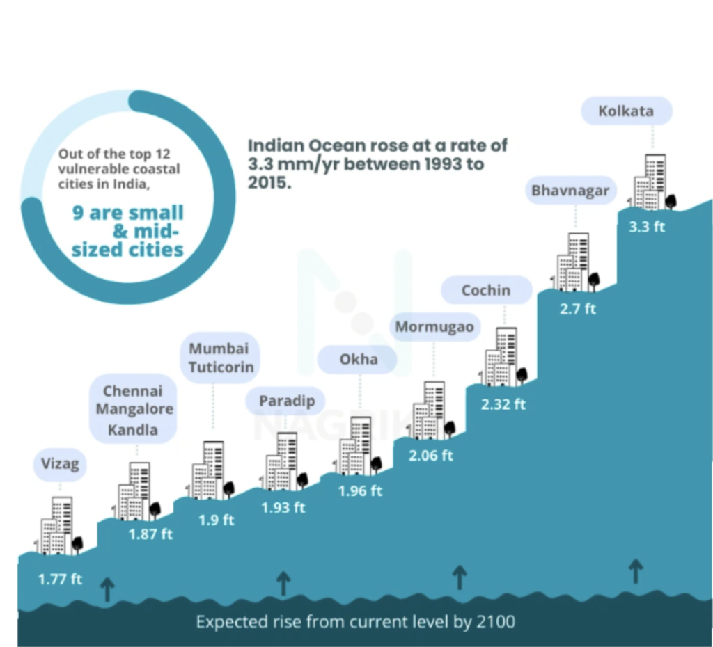
Beyond groundwater contamination, sea-level rise poses significant direct threats to coastal areas, including increased erosion, more frequent and intense flooding, and the loss of coastal vegetation and aquatic life. In India, 113 cities across nine states are at risk of submergence due to sea-level rise by 2050, with 109 of these being small and mid-sized coastal cities. Densely populated mega-cities like Mumbai and Kolkata are particularly vulnerable to these impacts.
The consequences of saltwater intrusion and coastal inundation extend broadly. The degradation of groundwater quality directly contaminates drinking water sources and can lead to an increase in waterborne diseases such as diarrheal cases and cholera outbreaks. These impacts also extend to agricultural lands, reducing yields, and severely affecting fragile coastal ecosystems, including vital mangrove forests like those in the Sundarbans. Coastal regions face a synergistic combination of climate impacts that exacerbate water insecurity. Sea-level rise directly causes physical changes like coastal erosion and increased flooding. Simultaneously, rising sea levels and altered rainfall patterns (leading to reduced groundwater recharge) drive saltwater intrusion into freshwater aquifers.
This creates a dual threat for coastal populations: direct inundation of land and the loss of access to potable and irrigation-suitable freshwater sources, impacting both water quantity and quality. The consequences cascade to public health (waterborne diseases), agriculture (reduced yields), and fragile coastal ecosystems (mangrove loss, biodiversity decline). The current lack of targeted research for smaller coastal cities further amplifies their vulnerability. Therefore, coastal adaptation strategies in India must be comprehensively multi-faceted, addressing both physical defenses against rising waters and innovative solutions for freshwater supply. There is an urgent need for localized, data-driven research and policy responses, coupled with enhanced citizen engagement, to effectively build resilience in these highly vulnerable regions.
Major Climate Change Impacts on India’s Water Resources
| Climate Impact Category | Specific Consequences for Water | Broader Socio-Economic/Environmental Effects |
| Changing Monsoon Patterns | Irregular rainfall, increased floods/droughts, reduced SWM intensity, groundwater depletion. | Reduced agricultural yields, food insecurity, livelihood loss, increased migration, economic burden, export restrictions. |
| Himalayan Glacial Retreat | Long-term decline in river base flows, increased Glacial Lake Outburst Flood (GLOF) risk, reduced year-round water supply. | Threats to agriculture, drinking water, industry, hydropower generation, infrastructure damage, water conflicts, ecological imbalance. |
| Sea Level Rise | Saltwater intrusion into groundwater, groundwater contamination, reduced freshwater availability. | Increased coastal erosion, more frequent/intense flooding, loss of coastal vegetation/aquatic life, health risks (waterborne diseases), reduced agricultural yields, ecosystem degradation. |
Conclusion
India’s water security is a critical national priority, shaped by intense internal pressures, complex regional dynamics, and the growing impacts of climate change. Declining per capita water availability and widespread pollution threaten public health, economic stability, and social equity. Regional water management involves navigating shared rivers with China, Pakistan, and Bangladesh, underscoring the importance of cooperative dialogue and resilient frameworks to maintain stability and sustainable resource sharing. Climate change further compounds these challenges through erratic monsoons, accelerated glacial melt, and rising sea levels, heightening vulnerabilities across sectors.
In response, India is pursuing a multi-pronged strategy combining policy reforms, technological innovation, and diversified financing. Major initiatives like the Jal Jeevan Mission, Namami Gange Programme, and Jal Shakti Abhiyan are expanding rural piped water access, rejuvenating rivers, and promoting water conservation practices such as rainwater harvesting and groundwater recharge. Advanced treatment technologies like Membrane Bioreactors and phycoremediation are being deployed to enhance water quality and management efficiency. Innovative financing tools, including green bonds and blended finance, are mobilizing investments and encouraging public-private partnerships to close critical infrastructure gaps.
Yet, these efforts face challenges such as fragmented governance, funding limitations at local levels, and public acceptance of treated wastewater reuse. Addressing the geopolitical dimension requires strengthening water-sharing agreements through legally binding treaties, transparent data exchange, and robust dispute resolution that can withstand political fluctuations. Ultimately, securing India’s water future demands sustained political commitment, cross-sector collaboration, and a societal shift toward recognising water as a precious, finite resource to be managed equitably and sustainably for generations ahead.
Also Read: Water conservation in India: Key trends & current landscape
Subscribe to our Newsletter
Subscribe today for free and stay on top of latest developments in Cleantech domain.